
The rise of drones on highways is set to transform road safety and monitoring on Italy’s A15 motorway. With the introduction of special “nests” designed to deploy and manage these drones, authorities aim to revolutionize traffic control and accident prevention. This initiative places Italy at the forefront of integrating drone technology with infrastructure management, promising safer journeys for all commuters.
Why Drones on Highways Are Gaining Attention
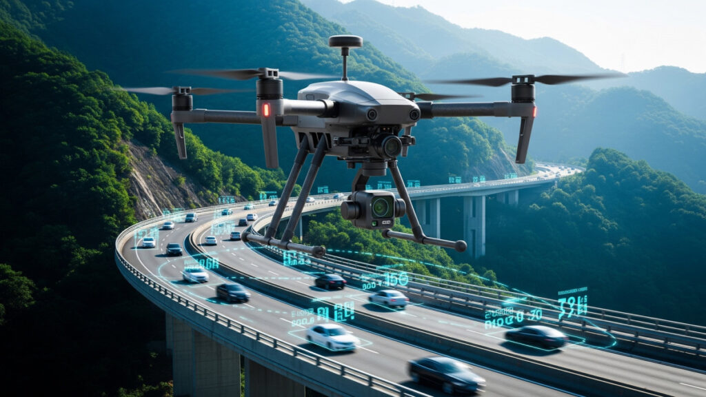
The concept of using drones on highways is rapidly becoming a hot topic as governments and transport agencies worldwide seek innovative solutions to improve road safety. The A15, the crucial route connecting Parma to La Spezia, is one of the first motorways in Italy to embrace this cutting-edge technology. These drones are not just flying gadgets; they serve a critical role in monitoring traffic flow, rapidly detecting incidents, and assisting emergency responders.
Traditional traffic monitoring heavily relies on roadside cameras and patrol units that have limitations in reaction speed and coverage. The deployment of drones offers a versatile and mobile eye in the sky that can reach any section of the highway quickly, providing real-time data to the control centers. This capability has captured the attention of security experts and tech enthusiasts alike, fueling discussions about the future of autonomous monitoring systems.
Drones on Highways: How the New Safety “Nests” Will Operate
The innovative “nests” for drones act as automated launch and recovery stations strategically placed along the A15 highway. These nests provide a secure base where drones can take off and land autonomously, recharge, and undergo maintenance checks without human intervention. This system ensures that drones are always ready to be deployed quickly whenever there is an event requiring aerial surveillance.
Equipped with high-resolution cameras and sensors, these drones fly predetermined routes to scan for anomalies such as traffic jams, accidents, or debris on the road. The data they capture feeds directly into the motorway’s control systems, allowing operators to make well-informed decisions and coordinate emergency services more effectively. The nests also store weather and flight data to optimize drone operations under various conditions, enhancing reliability and safety.
The Three Stages of the A15 Drone Project for Drones on Highways
The ambitious project unfolds in three primary phases designed to gradually integrate drones into the highway management ecosystem:
- Pilot Implementation: Initial deployment tested drone flights over selected highway stretches, focusing on monitoring traffic and detecting minor incidents.
- Expanded Coverage: Building on pilot feedback, additional nests and drones were introduced to extend aerial oversight, covering the entire length of the A15.
- Full Operational Integration: The final phase sees drones fully integrated with motorway control centers, enabling autonomous real-time incident management, rapid intervention coordination, and enhanced traffic flow optimization.
Each stage was carefully designed to study the practical challenges of drone operation near busy highways and address them while prioritizing safety, data security, and minimal disruption to road users.
How Many Drones Are in Operation and Their Strategic Locations
Currently, the A15 highway corridor operates a fleet of several drones, each assigned to specific segments between Parma and La Spezia. These drones rotate from the strategically located nests to ensure continuous surveillance coverage along the busiest parts of the motorway.
The positioning of nests took into account factors such as traffic density, accident history, and proximity to emergency services. This strategic spread allows quick response times and comprehensive monitoring, ensuring that no critical event goes unnoticed. Drones operate both during the day and in limited night-time scenarios with the support of infrared sensors, expanding their utility beyond conventional monitoring hours.
Personnel Training and the Human Element in Drone Operations on Highways
While much of the drone operations are automated, a key component of the project is the involvement of trained specialists responsible for the oversight and analysis of drone data. These professionals receive specialized training in drone piloting, data interpretation, and emergency coordination to complement the technological infrastructure.
Regular training ensures that personnel can efficiently intervene during complex incidents, system malfunctions, or weather disturbances that may affect drone flights. This human element maintains operational safety and guarantees that the technology supports, rather than replaces, human judgment in critical situations.
Read also : Galaxy S26 Ultra debuts magic pixels and screen recording
The integration of drones on highways marks a new era in road safety for the A15, combining technological advancement with practical infrastructure management. By deploying aerial drones from “nests” for 24/7 monitoring, authorities enhance their ability to respond to emergencies swiftly, prevent accidents, and manage traffic flow effectively. For daily commuters and transport operators alike, these developments promise safer, smoother journeys on one of Italy’s key motorway routes.
As drone technologies and autonomous systems evolve, their role on highways is expected to expand globally, setting new standards for traffic surveillance and public safety. The A15 drone project serves as an inspiring example of how smart technology can address real-world challenges, offering a compelling glimpse into the future of mobility management.